Sunday, December 11, 2005
'A Moment of Silence For Terrorists'
Somehow I missed this:
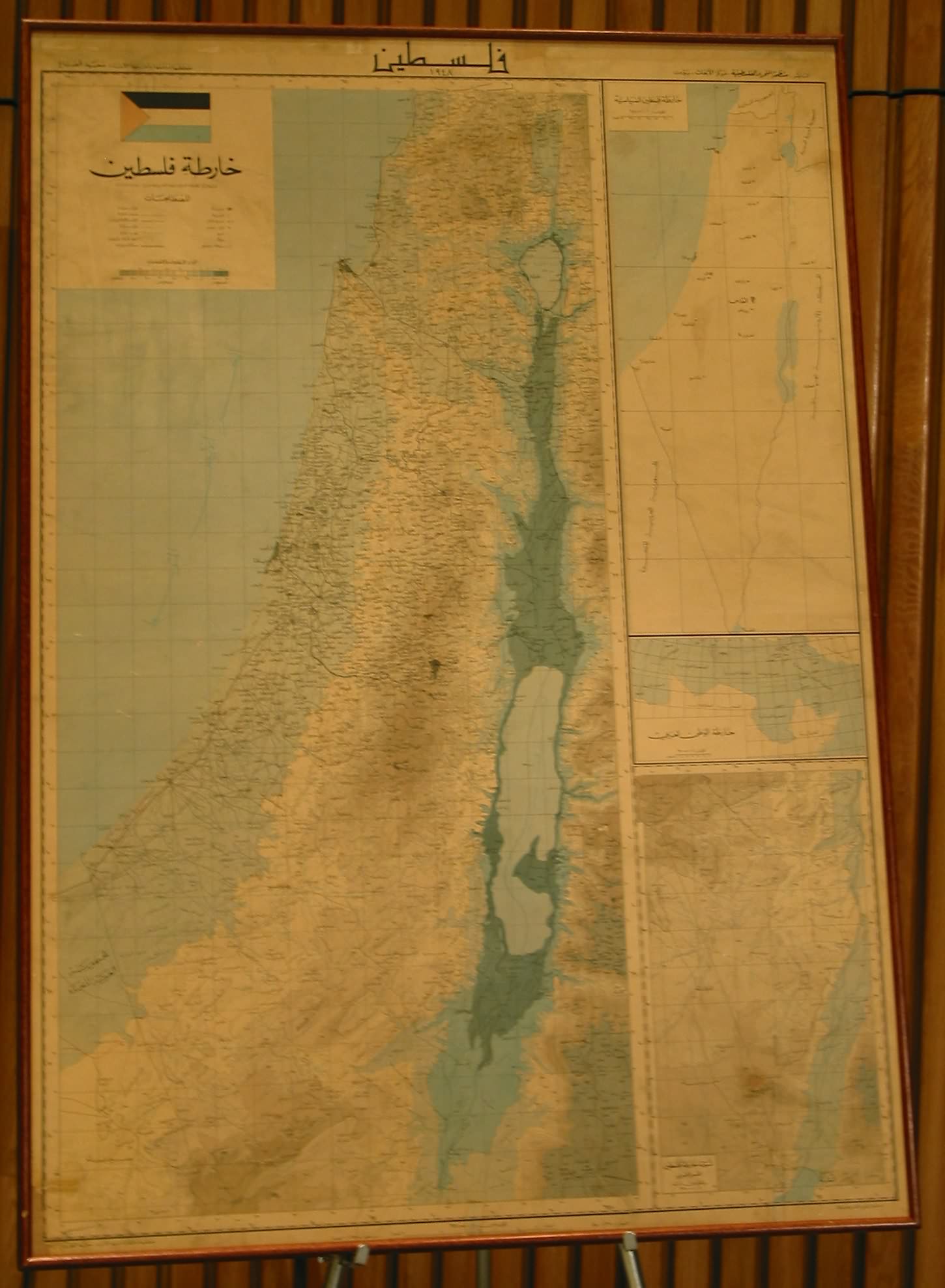
The United Nations held a "Day of Solidarity with the Palestinian People" last week. A large map of “Palestine,” with Israel literally wiped off the map, featured prominently in the festivities.Take a closer look at the map. Even if you can't read the Arabic title "Palestine" at the top (I can't, actually), the PLO flag is unmistakable... as is the placement of the map between the UN flag and a similarly-sized PLO flag, at the UN General Assembly.
At the start of the ceremony, the dignitaries present asked attendees to observe a moment of silence. "I invite everyone present to rise and observe a minute of silence in memory of all those who have given their lives for the cause of the Palestinian people," the master of ceremonies said, "and the return of peace between Israel and Palestine."
Anne Bayefsky, who reported on the event for the Eye on the UN organization, said that the ceremony's wording was aimed at giving honor to the worst of Palestinian terrorists. "It was a moment ... crafted to include the commemoration of suicide-bombers,” she wrote.


It's hard to imagine an analogous event, much less one getting as little attention as this has. If the UN had chosen to side with Syria against Lebanon, displaying a map that showed all of Lebanon as part of Syria -- in spite of the protestations of Lebanon, which is (and long has been) a UN member -- would that have been acceptable? Or, to put the shoe squarely on the other foot, suppose the UN had displayed a map of Israel that showed the Golan Heights and the West Bank as being part of Israel? (Legally they are. The Golan Heights were formally annexed by Israel in 1981. And Israel may unilaterally give up portions of the West Bank to the Palestinians eventually, but she hasn't done so yet; so the West Bank still constitutes territory from which a war was launched against Israel in 1967, which Israel captured in that war and therefore has every right to keep.)
For the UN to deny the existence of a member-state, in the name of a group that is not a member, is not merely vile and reprehensible. It also makes a mockery of everything the UN claims to stand for.
Oh, and by the way, take a closer look at the 'moment of silence' photo as well. Kofi Annan was there (front row, third from the right), and he stood along with everyone else... to 'commemorate' the murderers of women and children, Arab and Jew alike.
Is this the UN's way of displaying 'moral equivalence', given Israel's increasing stature at the UN these days?
If my Photoshop skills were up to it, I'd love to produce a photo of southeastern New York... with the UN building removed, and a Starbucks in its place.
(Hat tip: The Broadsword, which linked to Israel National News, which in turn pointed to Eye on the UN.) Anne Bayefsky has written about this -- and is a frequent contributor to the Wall Street Journal, among other places, on UN-related topics.)
UPDATE: Eye On The UN has a larger (hi-res) photo of the map here. Zoom in on it, and you'll see that the map (in Arabic numerals) is dated 1948... the last year in which a territory called "Palestine" existed (and before the state of Israel came into being):

I'm surprised; this is more honesty than I expected. (We have certainly seen more modern maps of the Middle East, with Israel erased and Palestine substituted.) Perhaps the UN insisted on using a map from UN archives... in which case, this was the most recent map of "Palestine" that could be found.
In other words, by showing a factual (albeit 57-year-old) map, the UN was simply misleading, and not actually lying through their teeth. I have to give 'em credit for that, I suppose...
UPDATE II: My wife points out that one of the maps linked above comes from www.palestine-net.com, where one can also find this lovely paragraph:
Land and Borders:Isn't that nice? "Currently under occupation", as though this status was but a minor aberration in the historical record, with the occupiers not worth naming or otherwise mentioning.
Palestine, currently under occupation, is located on the East coast of
the Miditerannean Sea, West of Jordan and to the south of Lebanon. The
territory of Palestine covers around 10,435 square miles (almost same
size as the state of Vermont in the USA - that is, pretty small.) [1]
Out of this territory, there are 10,163 square miles of land area. The
rest is water: half of the area of the Dead Sea (al-BaHr al-Mayyit),
Huleh Lake (BuHayrat al-Huuleh) which was dried by the occupation and
Tiberias Lake (BuHayrat Tabariyyah) which is also known as the Sea of
Galilee (BaHr al-jaliil).
Please note, also, that "Palestine" is not defined as the West Bank and Gaza Strip territories, which is what the Palestinians publicly claim to want. No, "Palestine" here is defined as everything west of the Jordan River -- all of Israel, in other words.
It's bad enough when the Palestinians claim land as theirs that was never theirs to begin with, and are unwilling to do anything to bolster their claims other than to kill people. But why must the UN swallow these fantasies wholesale?
One more thought. This "Day of Solidarity With the Palestinian People" is apparently an annual event... held every year on November 29th. Why on that date? Is that the date that the Palestinian people had their land taken from them, or something?
No. That's the date -- November 29, 1947, to be exact -- when the area now known as Israel was partitioned into a Jewish state and an Arab state, by the UN General Assembly! (At the time, they were called "a Jewish Palestinian state" and "an Arab Palestinian state". The local Arabs were not called Palestinians to distinguish them from Jews until much later; nor did they then call themselves that.)
In other words, if the UN is observing the date of November 29th as the date that an injustice was perpetrated, it was an injustice perpetrated by the UN itself. Could the irony be any stronger?
UPDATE III: Yes, it could. According to John Hinderaker at Power Line, and the incomparable Anne Bayefsky at Eye On The UN, it wasn't an historical map at all:
The United Nations, which houses the map in its Division for Palestinian Rights, has not made the map available for confirmation of its Arabic text. However, some of the words have now been deciphered and to the best of our knowledge include the following: "Palestine's Political Map, The Palestine Liberation Organization, the Center for Research, Beirut".I think it's not quite as bad as all that -- see my comments, above, in re the date printed on the map. So perhaps this PLO-printed map was itself a reprinting of a 1948-era map, complete with the date.
[So] it turns out that the map was not historical at all. It was "Palestine's Political Map." And it wasn't a mere early map the UN found in a history book. It was a map which must have been produced post-1964, since the Palestine Liberation Organization (PLO) was created June 2, 1964.
This doesn't make the UN look any better, though. On one hand, they have Israel, a member-state of the UN since 1948, and a country that has been under the tightest scrutiny -- by the UN, among others! -- for most of that time. On the other hand, they have the Palestinians, who are not a member-state of the UN at all, and who are known for playing fast and loose with the facts... in addition to being dedicated to the utter destruction of a particular UN member-state.
Given that choice, whose maps would you use? If you're the UN, the choice is obvious, isn't it? And if fairness and integrity are at all important to you, the choice is just as obvious -- do the opposite of whatever the UN does.


